There are many questions about precolonial Aboriginal societies.
Were settlement patterns the same across the entire continent?
Was population density higher in certain regions?
Was population density linked to geography? With certain resources?
If so, in what way?
Here we look at two sources for some statistics and for some general patterns.
The first is Harry Ladrounos and his Aboriginal Spatial Organization and Population: South Western Victoria Reconsidered, Archaeology & Physical Anthropology in Oceania, Oct., 1977, Vol. 12, No. 3, pp. 202-225.
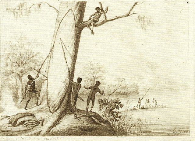
Ladrounos is looking at southwestern Victoria which happens to have a relatively high population density compared with much of the continent.
He gives a total population estimate of c. 7,900 at the time of European contact.
His population density for this region is 1 person per 3.6 square kilometers.
This is much higher than population densities for the arid areas of Australia. His figure for these regions is 1 person per 90.6 – 259 square kilometers.
However, the density in southwestern Victoria is lower than in even more well-resourced coastal locations such as East Arnhem Land which has a figure of 8 people per square kilometer.
Ladrounos notes that nomadism is more closely liked to open woodland areas with more dispersed resources while semi-sedentary life is associated with marsh land (p. 220).
He also notes that one area that was uninhabited was the Cape Otway rainforest.
In Victoria it seems that forests were not preferred by indigenous peoples.
The second source is Peter J. Dowling’s ‘Violent Epidemics: Disease, conflict and Aboriginal population collapse as a result of European contact in the Riverland of South Australia’ (1990).
Dowling’s study area is downstream from where the Murray and Darling Rivers intersect.
These major rivers with their large fish resources saw high population densities – probably some of the highest in the continent.
Dowling writes “Aboriginal population density varied throughout the continent and the main determinants appear to have been reliable water and food resources…the well-watered Murray River corridor was an especially favourable environment for hunters, fishers and collectors…able to sustain much higher densities” (pp. 47/48).
Charles Sturt traveled through the area in 1830. Eight years later, Eyre also traveled through the area.
The region would become important as a stock route between Sydney and Adelaide.
Dowling quotes figures given by Sturt.
- Above the junction with the Murray, Sturt encountered more than 120 individuals.
- West of Robinvale he reports more than 150.
- By far the greatest number seen by Sturt was where the two mighty rivers combined – 600.
- West of the Rufus River he found 250 (all figures p. 49)
In the early 1840s Eyre was the Resident Protector of Aboriginies at Moorundie on the Lower Murray. He had more time to meet and get acquainted with the Aboriginals of that area. During this time Eyre believed that the population density of the area was between 1.9 and 2.5 people per kilometer of river (p. 53).
Dowling writes further, “The most densely populated areas of Aboriginal Australia were the tropical north and temperate east coasts, the southeastern coast and hinterlands and the inland waterways. Of them all, the Murray/Darling river system with its associated hydraulic components was the most densely populated region of the continent” (p. 55).
Dowling lists figures from Radcliffe-Brown (1930) in which, interestingly, the estimate for Western Port (Victoria) is 19.4 people per square kilometer and for the ‘Melbourne region’, the figure is 24.3 per square kilometer.
What can we take away from all of this?
Population density did indeed change depending on where you were in the continent.
Abundant fresh water and food were essential in supporting high populations.
Major rivers, floodplains and marshlands were sites of much activity.
The tropics may be a different story, but in Victoria forests were not a preferred geographic area and there was relatively less activity taking place there.

Leave a comment